
The Limits of Satellite Navigation: GPS Challenges in the Arctic
More human activity is expected in the Arctic region in the coming decades. However, satellite navigation remains inaccurate and difficult in this region.
More human activity is expected in the Arctic region in the coming decades. However, satellite navigation remains inaccurate and difficult in this region.
Note: This article was updated on August 7th to correct some inaccuracies and better characterize the reliability of GPS navigation in the Arctic.
Wherever you are likely reading this from, you can probably take for granted that you can use the Global Positioning System (GPS), probably even on your phone, to map out directions to a nearby destination.
However, GPS is not quite as global as its name suggests—the technology is unreliable in the Arctic, an area on Earth that is slowly seeing more human activity due to tourism, research, and industry. As the ice recedes in the Arctic, the region may also become a more common passageway for ships. Accurate navigation is important in the Arctic for all of these situations, made especially crucial by the negative impacts accidents could have on the environment and the difficulty of rescue missions in the case of emergencies.

Average winter temperatures in the Arctic reach -40°F. Image courtesy of Paul Downey.
Why does GPS fail in the Arctic? What can we rely on for navigation in this frigid landscape? Here we provide you a basic primer and some solutions or alternatives that experts on satellite navigation have suggested.
GPS Basics
In case you’ve never had a reason to learn before, we’ll start with the basics on how GPS works in the first place. GPS is comprised of three major elements: a satellite constellation of at least 24 satellites, ground stations, and receivers (such as the one on your phone).
Ground stations are responsible for maintaining the satellite systems through monitoring and control of satellite orbital parameters, updating or correcting satellite parameters, tracking each satellite’s position, health monitoring, and activation of new satellites.
GPS satellites transmit their known location periodically and a receiver will then receive that information. If the receiver can “see” at least three satellites (receive a transmission from three satellites) then the longitudinal and latitudinal position can be calculated using triangulation (2D position). If a fourth satellite is used, then the attitudinal distance can also be calculated (3D position).
A combination of the Doppler effect and special relativity come into play with these calculations—the clocks on the satellites in orbit move more quickly relative to the one on your phone, which is also much less accurate. But through these calculations, your position can still be reasonably ascertained.
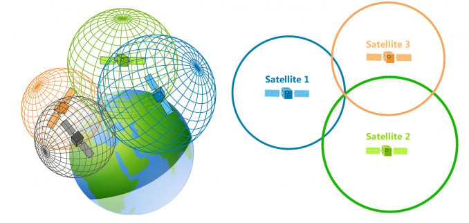
Image courtesy of GIS Geography.
For the GPS satellites, precise timing and synchronizing is very important for accurate positioning, which is why atomic clocks are used on board. On GPS satellites, in particular, atomic clocks are usually based on cesium and rubidium, with time being tracked by the change in energy states of the atoms. Ground stations will periodically re-adjust the time onboard GPS satellites since atomic clocks will still drift by about 10 nanoseconds every day. These highly accurate clocks are also used to synchronize the time of systems on Earth, including credit card and debit transactions.
As a final note, GPS (known as NAVSTAR by the US Department of Defense) is one system that is in use, but there are a few others including Galileo (Europe), GLONASS (Russia), and BeiDou (China). Typically, these systems are interoperable.
So, that’s some of the most basic information on how the system works together
Orbital Inclination Limitations
The first barrier to GPS being reliably available in the Arctic is due to the orbital inclination of the satellites involved. The satellites follow one of six orbital planes, all at an inclination of roughly 55 degrees, though some other satellite navigation systems, specifically Galileo and Glonass, have higher inclinations of 56 and 64.8 degrees, respectively. The Arctic circle, meanwhile, begins at about 66.5 degrees north. At these high latitudes, several satellites are still visible at any given time, but they never pass directly overhead. In fact, when using GPS right at the pole, the highest elevation GPS satellite you would see is about 45 degrees above the horizon.
As a result, according to Anna B.O. Jensen and Jean-Paul Sicard in their article "Challenges for Positioning and Navigation in the Arctic", this situation leads to "better horizontal satellite geometry, but worse vertical satellite geometry compared to the situation at mid and low latitudes."
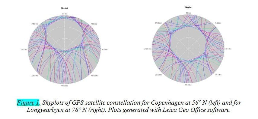
Image courtesy of MyCoordinates.
There could be several reasons this is the case. First, typically there are not a lot of people in the polar regions, so orbiting in planes that would make satellites visible may not be the most effective use of resources. Each satellite has to be maintained and replaced occasionally. Since humans mostly populate the regions between 55 degrees north and south, it may have just made sense to focus on this area. Second, launching into polar orbit is also more difficult, requires more energy, and is more expensive. So, overall the cost-benefit analysis may not have been favorable.
Augmentation systems exist that can work in parallel with satellite positioning, but the satellites that operate these systems also tend to be difficult to “see” in the Arctic, since they are in Geo-sync Earth orbit, most likely near the equator.
Ionospheric Activity Can Be Scintillating (in a Bad Way)
Finally, the Arctic region experiences a lot of ionospheric activity that fluctuates in intensity based on the solar cycle. Every 11 years, there is a rise in ionospheric activity which can produce beautiful aurora borealis but also causes a lot of problems with electronics in general.
GPS satellites are not impervious to ionospheric activity, which can cause signal scintillation, creating changes in the amplitude or phase of signals. This can cause errors in timing, which then translates to errors with positioning calculations.
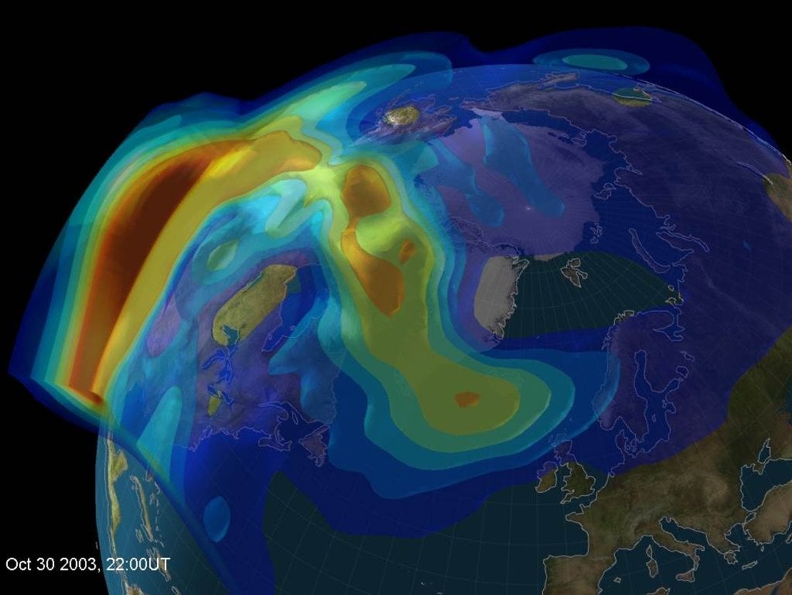
Ionosphere activity gradient. Image courtesy of the European Space Agency.
Future Solutions
Quite a bit of research is being done on various methods that could improve satellite positioning: developing more accurate atomic clocks, increasing robustness against scintillation, implementing more capable onboard computing—just to name a few.
For Arctic applications, many solutions have been proposed. One such solution is the implementation of multi-channel L-band frequencies in satellite navigation systems. This would capture more data for positioning calculations and could overcome ionospheric interference if multiple frequencies are being used.
Inertial Navigation Systems (INS) can also be paired with satellite navigation, which can make up for data gaps during scintillation. However, INS tend to have difficulties in maintaining accurate heading but may not be a significant factor if scintillation disruptions happen in relatively short bursts.
Finally, medium Earth orbit augmentation satellite constellations could also be implemented to improve the accuracy of GPS in the Arctic. Augmentation systems such as the Wide Area Augmentation System (WAAS) in the US are used in compliment with GPS to provide even more accurate positioning data, with a particularly adapted use in aviation.
If you somehow find yourself in the Arctic and you can’t get an accurate GPS lock on your phone, now you know why.
Have you worked with GPS systems or satellite technology? Chime in using the comments below and share your experiences.
Special thanks to Dr. Penina Axelrad for her input.
Feature image courtesy of Safety4Sea.


Great article! I’m now more empathetic towards Santa’s, seemingly yearly, delays. Small correction, GPS uses trilateration rather than triangulation. The orbital inclination is news to me, thanks for sharing!