Facebook
 Google
 GitHub
 Linkedin
New LiDAR Improves Testing, Satellite Vision, and Autonomous Trucking
Innovative LiDAR solutions with enhanced accuracy and extended range may transform the testing, mapping, and trucking landscape—and beyond.
Light detection and ranging (LiDAR) plays a pivotal role in modern vehicles for navigation with high precision. As the demand for safer and more efficient autonomous vehicles grows, the industry witnesses more innovations in LiDAR technologies.
At the heart of these solutions lies emerging hardware, such as laser diodes, optical systems, and signal processing units, that enhances the performance and accuracy of LiDAR sensors. They pave the way for LiDAR systems to capture high-resolution 3D data with exceptional range, precision, and reliability.
In parallel to the advancements in LiDAR sensors, LiDAR testing is also gaining significant attention. LiDAR testing solutions use target simulators, precision optics, and high-speed laser diodes to generate realistic scenarios for testing LiDAR sensors. By accurately emulating dynamic objects and challenging environments, these hardware-driven testing solutions enable automotive developers to assess the performance, accuracy, and reliability of LiDAR sensors under various real-world conditions.

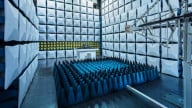
Outdoor and indoor LiDAR test setup scenarios. Image used courtesy of Keysight Technologies
This article focuses on cutting-edge LiDAR solutions and how they enhance performance to push the boundaries of what such sensors can achieve.
Keysight Revolutionizes LiDAR Testing
Keysight Technologies has expanded its autonomous driving test portfolio with a new LiDAR Target Simulator. With this addition, the company aims to address critical LiDAR sensor testing challenges.
Traditionally, LiDAR testing is performed using real-world scenarios or simplified static environments, for which the designers need large floor spaces and use traditional target boards. These approaches often have limitations in terms of flexibility, scalability, and repeatability.

Keysight E8717A LiDAR Target Simulator (LTS). Image used courtesy of Keysight
Keysight's new E8717A LiDAR Target Simulator (LTS) is a compact bench setup that simulates test targets at defined distances from 3 meters to 300 meters and reflectivity from 10% to 94%. Its algorithms generate analytics by sweeping these target distances and reflectivity. The LTS is fully automated using a cobot powered by Keysight PathWave Test Executive for Manufacturing. The cobot provides precise device movement for field-of-view testing, and the testing software expedites the testing process and enhances productivity to enable mass production.
NuView LiDAR Satellite Expands Earth Observation
One LiDAR startup NuView aims to provide new insights on the Earth's surface with unprecedented precision and detail. Its LiDAR-based satellite approach allows for comprehensive and precise digital elevation models, aiding various applications across industries such as urban planning, agriculture, forestry, and environmental monitoring.

NuView’s vision is to annually map the planet’s surface by building dedicated commercial satellite constellations. Image used courtesy of Nuview
Nuview's LiDAR satellites can penetrate dense canopies and vegetation, providing accurate data that was previously inaccessible. This level of accuracy is particularly beneficial for applications such as land cover classification, change detection, and infrastructure monitoring. Additionally, Nuview employs advanced algorithms and machine learning techniques to extract meaningful information from LiDAR data, facilitating efficient analysis and interpretation for various industries and research purposes.
Nuview has so far raised $15M in funding (with one investor being actor Leonardo DiCaprio!) and plans to construct a group of 20 LiDAR satellites. These satellites are designed to produce an annual map of the Earth's entire surface with centimeter-level precision.
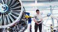
Luminar and Plus Partner to Enhance Autonomous Trucking
Vision-based LiDAR company Luminar Technologies and automated driving company Plus have partnered to improve the safety and automation of driving systems for manufacturers of commercial vehicles. Through a strategic partnership, Luminar will combine its LiDAR technology and Plus' AI-assisted driving software to deliver improved safety, efficiency, and autonomy to long-haul trucking operations.
At the core of this collaboration are Luminar's LiDAR sensors that provide precise perception and mapping capabilities for trucks. Luminar's Iris LiDAR meets the performance, robustness, and reliability requirements for class eight commercial trucks. It can detect as far as 600 meters ahead, which is around 20 seconds of visibility ahead at highway speeds.

Luminar's Iris LiDAR unit. Image used courtesy of Plus and Luminar
Plus' software combines LiDAR data and deep learning algorithms to improve perception capabilities, allowing intelligent decision-making and navigation in challenging driving situations. It encompasses lane keeping, adaptive cruise control, and nudging when next to an oversized vehicle. In addition, updates with new features are delivered via over-the-air software updates.
Related Content